
Upper vs Lower Table Rock: Best Rogue Valley Hike in Southern Oregon
Table of Contents
- Overview: Upper vs Lower Table Rock
- Upper Table Rock Hike Guide
- Wildlife & Wildflowers on Table Rock
- Lower Table Rock Hike Guide
- Practical Tips for Table Rock Trails
- Which Is Better: Upper vs Lower Table Rock in Southern Oregon?
- FAQs About Table Rock Hikes in Southern Oregon
- Closing
Overview: Upper vs Lower Table Rock
If you want two of the most accessible and rewarding Southern Oregon hikes, Upper and Lower Table Rock are top contenders. Both trails sit above the Rogue Valley and offer sweeping views, unique ecosystems, and a compact hike that packs a lot into a short amount of time.
Quick numbers to keep in mind: Upper Table Rock is about 1.25 miles to the top with roughly 700 feet of elevation gain. Lower Table Rock is a bit longer at about 1.75 miles. Combined, the two trails draw around 45,000 hikers per year, which tells you how popular they are.
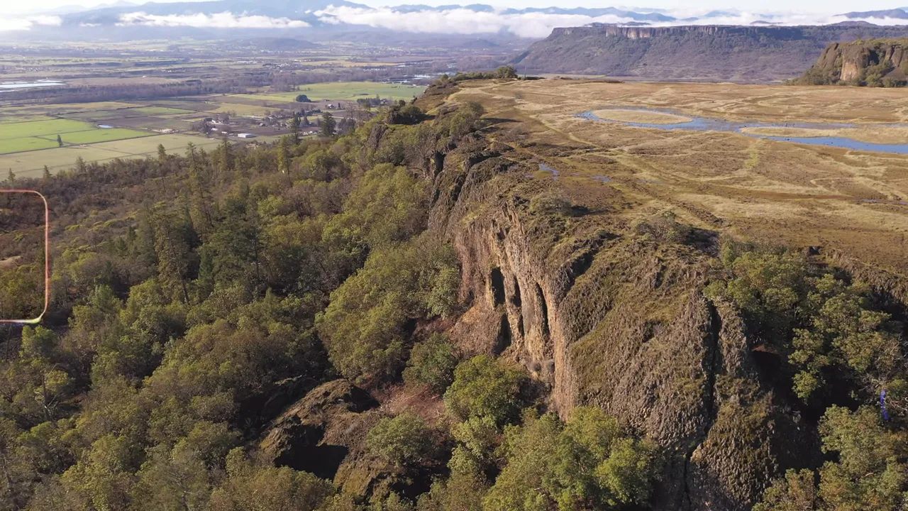
Upper Table Rock Hike Guide
Upper Table Rock climbs quickly and is very well maintained. Expect packed gravel and a short, steady ascent that most hikers finish in under 30 minutes. The final approach includes some rocky sections, but nothing overly technical.
Once on the plateau you’ll find trails that meander across the top. Elevation up here sits near 2,000 feet above sea level, so the views over the Rogue Valley are outstanding.
A couple of important things: the trail is popular in spring for wildflowers, and dogs are not allowed. Also watch the trail edges—poison oak lines a lot of the approaches, so keep to the path and know how to recognize it.
Wildlife & Wildflowers on Table Rock
The plateau’s unique geology—impermeable rock that traps groundwater—creates seasonal pools and a surprising mix of plants and animals. About 300 plant species and dozens of animal species have been recorded here.
In spring (March through May) the top explodes with wildflowers. Small vernal pools support rare species like fairy shrimp, a fascinating sign of this distinct ecosystem. If colorful blooms are your priority, plan your hike for peak spring.

Lower Table Rock Hike Guide
Lower Table Rock is the longer route and can feel steeper than expected. The trailhead turns off Table Rock Road onto Wheeler Road can be easy to miss, so keep an eye out. The hike still takes around 30 minutes if you keep a steady pace.
From the summit of Lower Table Rock you get a different vantage point—many hikers prefer this viewpoint because it offers sweeping lines of sight to Upper Table Rock and surrounding peaks. There also tends to be less poison oak along some sections, which is a practical win.
Practical Tips for Table Rock Trails
- Gear: Small daypack, sturdy shoes, water, and sun protection are all you need.
- Season: Spring for flowers; the trails are enjoyable year-round on clear days.
- Watch for poison oak: It grows along many trail edges—stay on the path.
- No dogs: Signs at both trailheads indicate pets are not allowed.
- Time: Plan 30–60 minutes roundtrip for each summit if you’re moving briskly; add more time to linger and explore the plateau.
Which Is Better: Upper vs Lower Table Rock in Southern Oregon?
Choosing a favorite depends on what you value. Both are fantastic Southern Oregon hikes, but if forced to pick one, many locals prefer Lower Table Rock for its viewpoint and slightly fewer poison oak patches. Upper Table Rock is an excellent quick climb with broad plateau trails and phenomenal spring wildflowers.
FAQs About Table Rock Hikes in Southern Oregon
How long are the Upper and Lower Table Rock hikes?
Upper Table Rock is roughly 1.25 miles to the top with about 700 feet of elevation gain. Lower Table Rock is around 1.75 miles and can feel a bit steeper and longer.
When is the best time to go for wildflowers?
March through May is peak wildflower season. The plateau’s pools and shallow groundwater encourage prolific spring blooms.
Are dogs allowed on the trails?
No. Both Upper and Lower Table Rock prohibit dogs. Signs are posted at the trailheads.
What should I be careful about on the trail?
Poison oak grows along much of the trail edges. Stay on the path and learn to identify the plant. Also watch your footing on the rockier final sections.
Which trail do locals prefer?
Preferences vary, but many pick Lower Table Rock for its viewpoint and slightly less poison oak. Both trails are outstanding additions to any list of Southern Oregon hikes.
Closing
Ready to get out there? These two Table Rock hikes are compact, scenic, and full of surprises—perfect examples of why Southern Oregon hikes keep people coming back.
Interested in buying a home in Southern Oregon? Reach out to me either thru call or text at 541-827-8767 and I'll guide you through neighborhoods, listings, and next steps. He’s happy to answer questions or schedule a meeting.
READ MORE: Southern Oregon Protected Land: Wilderness Rules, Real Risks, and How to Visit

Buying Southern Oregon
At Buying Southern Oregon, we are a dynamic team dedicated to helping you achieve your real estate goals. Combining Brian Simmons’ deep market expertise and Josh Berman’s strong negotiation skills, we provide personalized service and local knowledge to ensure a seamless and rewarding experience. Whether you’re buying, selling, or relocating, we’re here to guide you every step of the way and make your Southern Oregon real estate journey a success.
Watch Our Latest Video